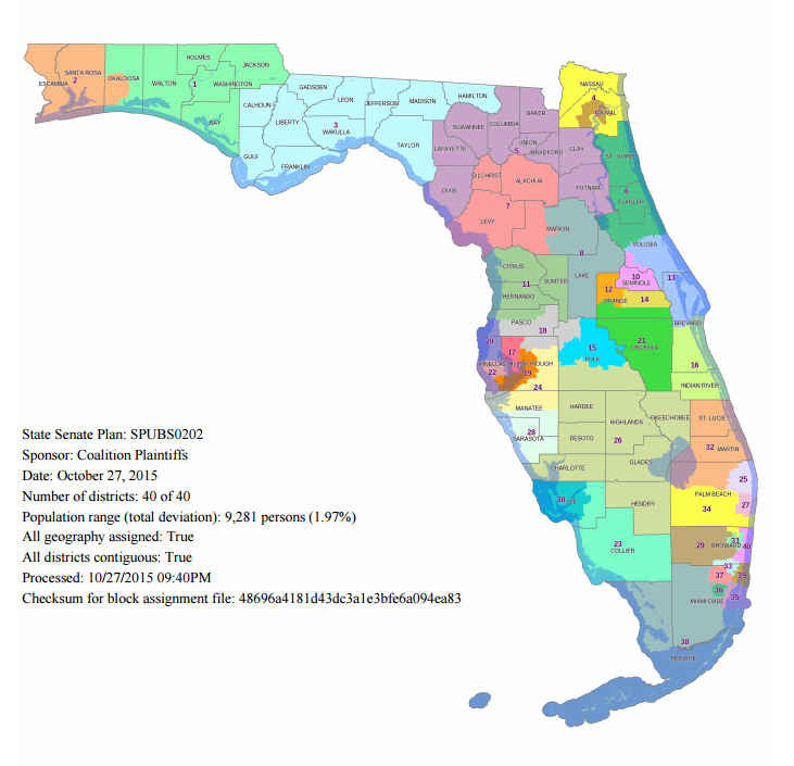
The coalition plaintiffs suing the Florida Legislature over the 2012 State Senate boundaries have opted to release one proposal they have for the Senate lines. The word from many is that the coalition may release another map, one that incorporates 2012 and 2014 primary data, which is an issue I have discussed on this blog. The map has several issues and it is definitely this writer’s opinion that some adjustments need to be made. Let’s take a look at some key details.
Partisan and Racial Breakdown
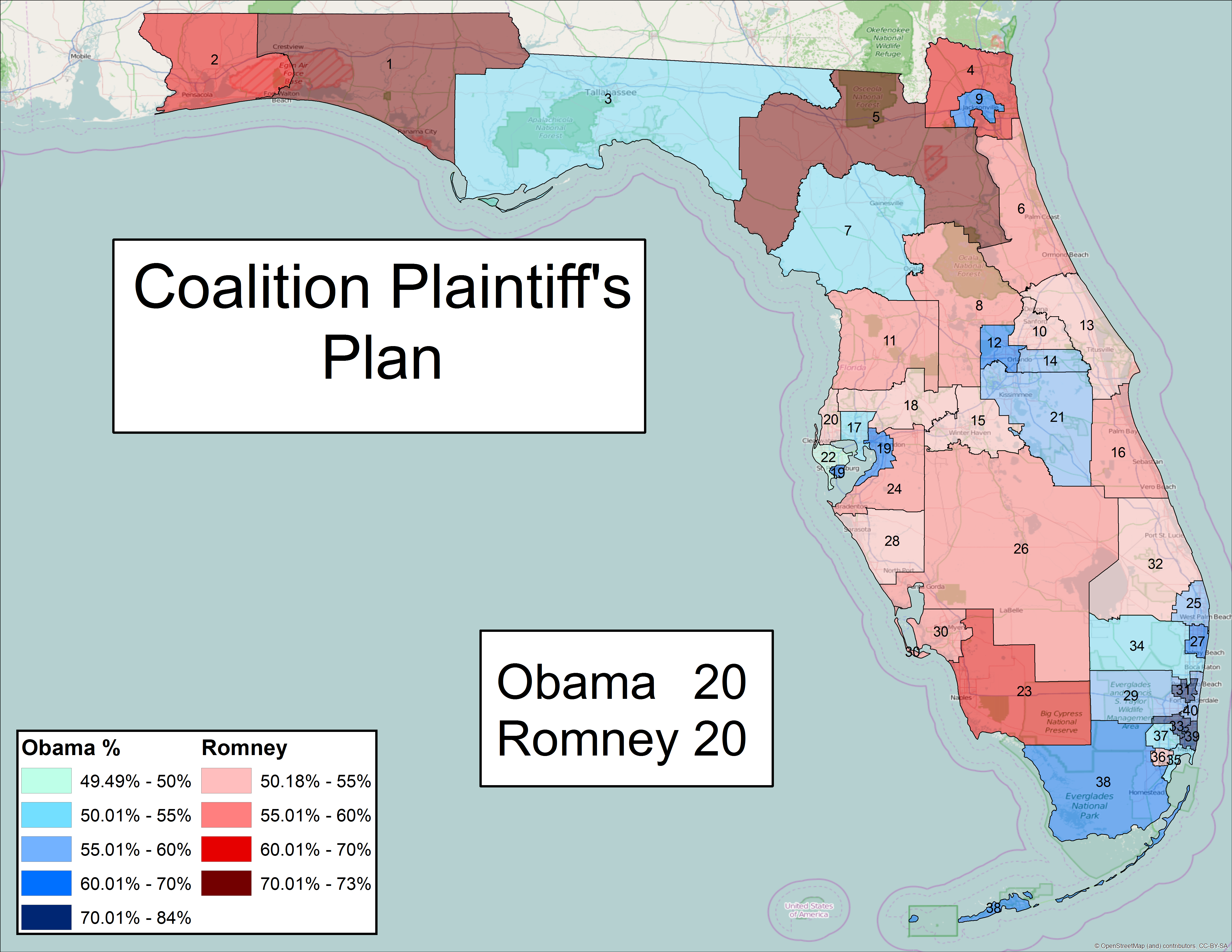
From a partisan standpoint, the map has 20 Obama districts and 20 Romney districts. This is the same number that base map 9070 had, and more than the 17 Obama districts under the 2012 plan. New Obama districts pop up in Orlando, Tampa, and Gainesville.
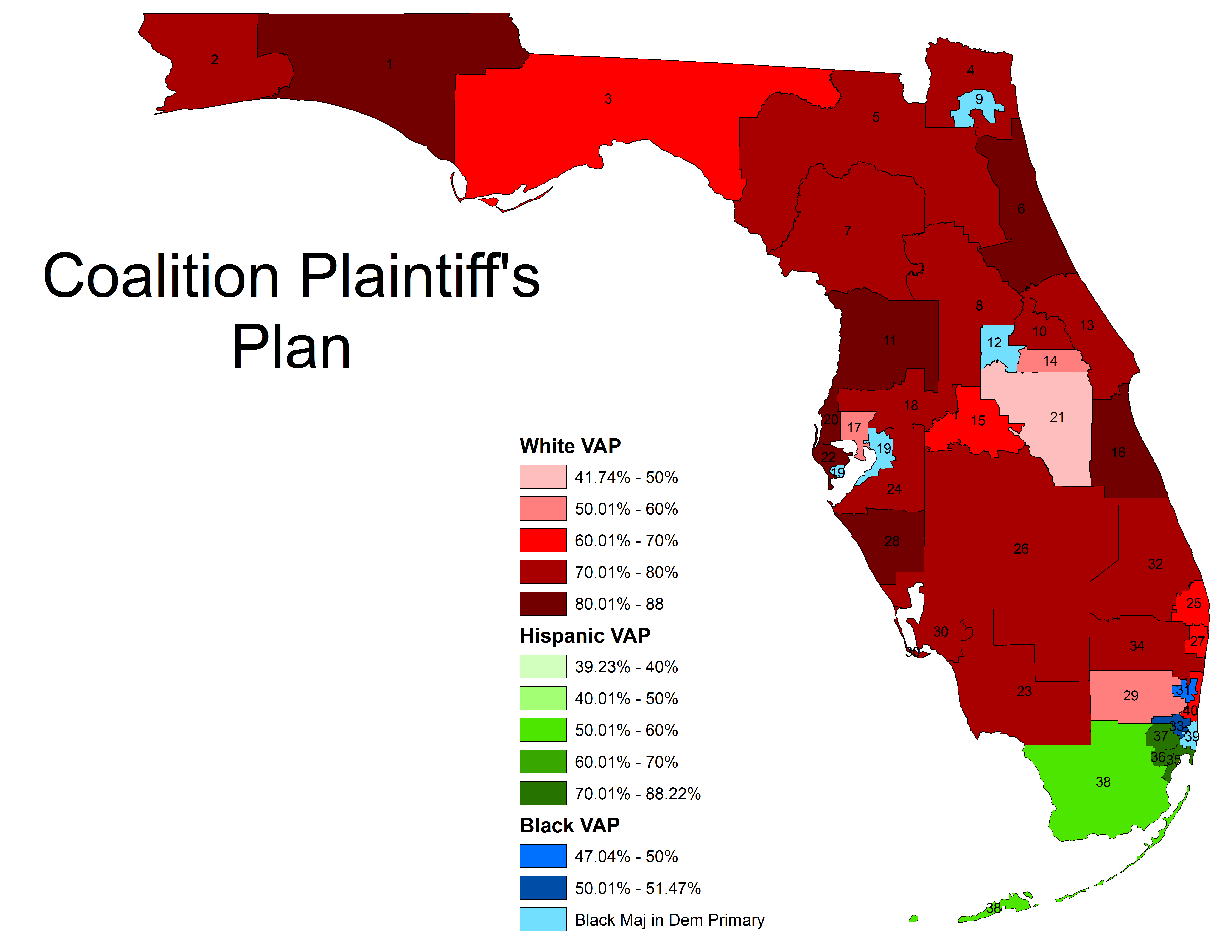
The racial makeup is similar to the six base maps, with 6 African-American seats and 4 Hispanic seats. However, the African-American seat in Broward is not majority black. I will cover that issue later in the article.
Regional Breakdown
Similar to how I broke down the base maps, I will go over this plan by region.
Northwest Panhandle
There are some odd moves made in the Western Panhandle. A bulge is made in Okaloosa, taking in territory in a way not done so before and in a very non-compact way.
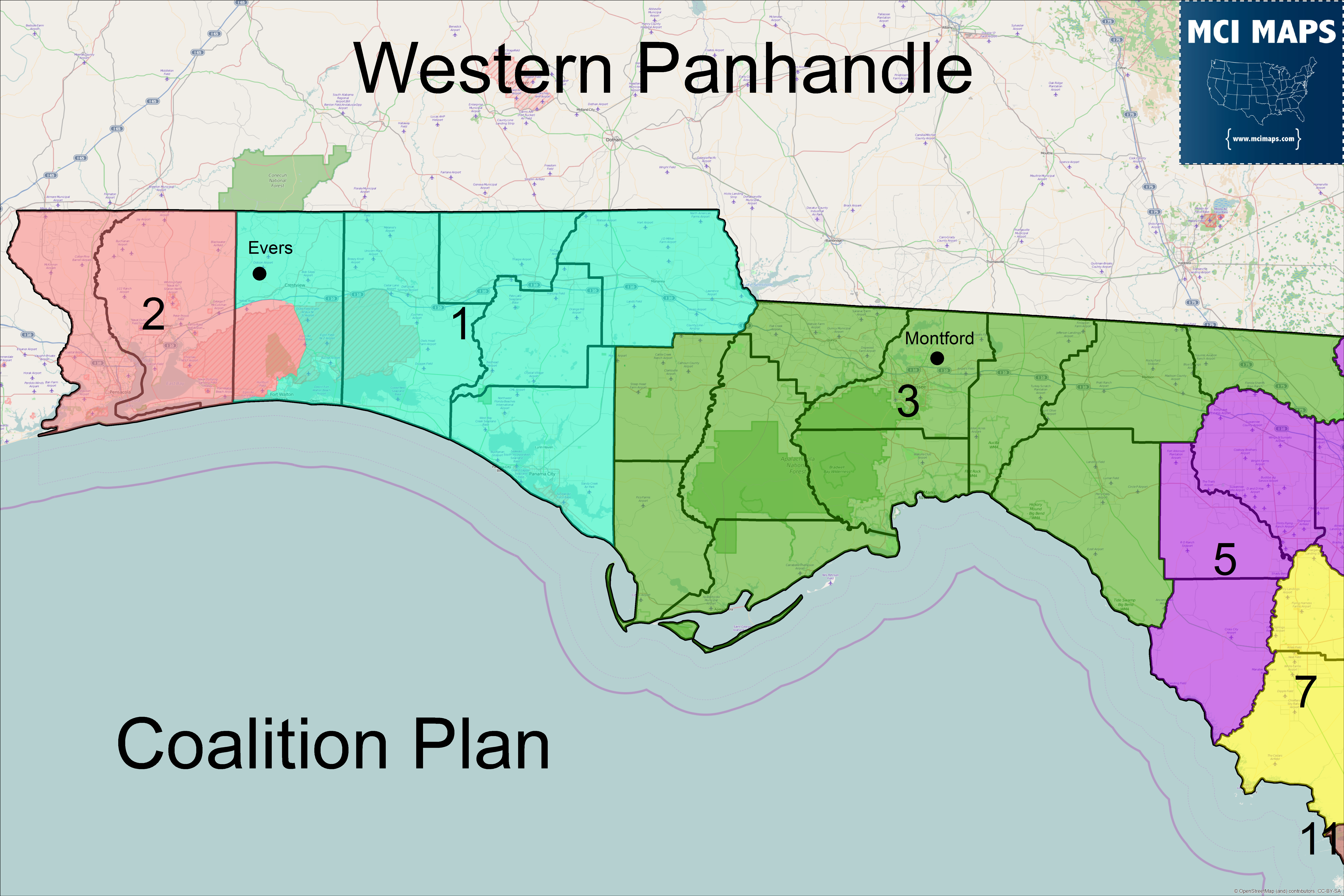
The bulge does not make a city whole or have any key political geographic reason behind it. The base maps favored either a North-South split or a more even cut of the county that took a western section off. This method is not compact and odd. One side-effect would be Evers would be in District 1 and paired against Matt Gaetz (unless one of them moves) for the Senate seat. Senate District 3 remains unchanged.
Northeast Florida
The Northeast Florida proposal has one of the Jacksonville configurations in the base maps, but not the one being used in the plan that just passed the State Senate today. District 6 is also the same as the Senate’s proposed plan.
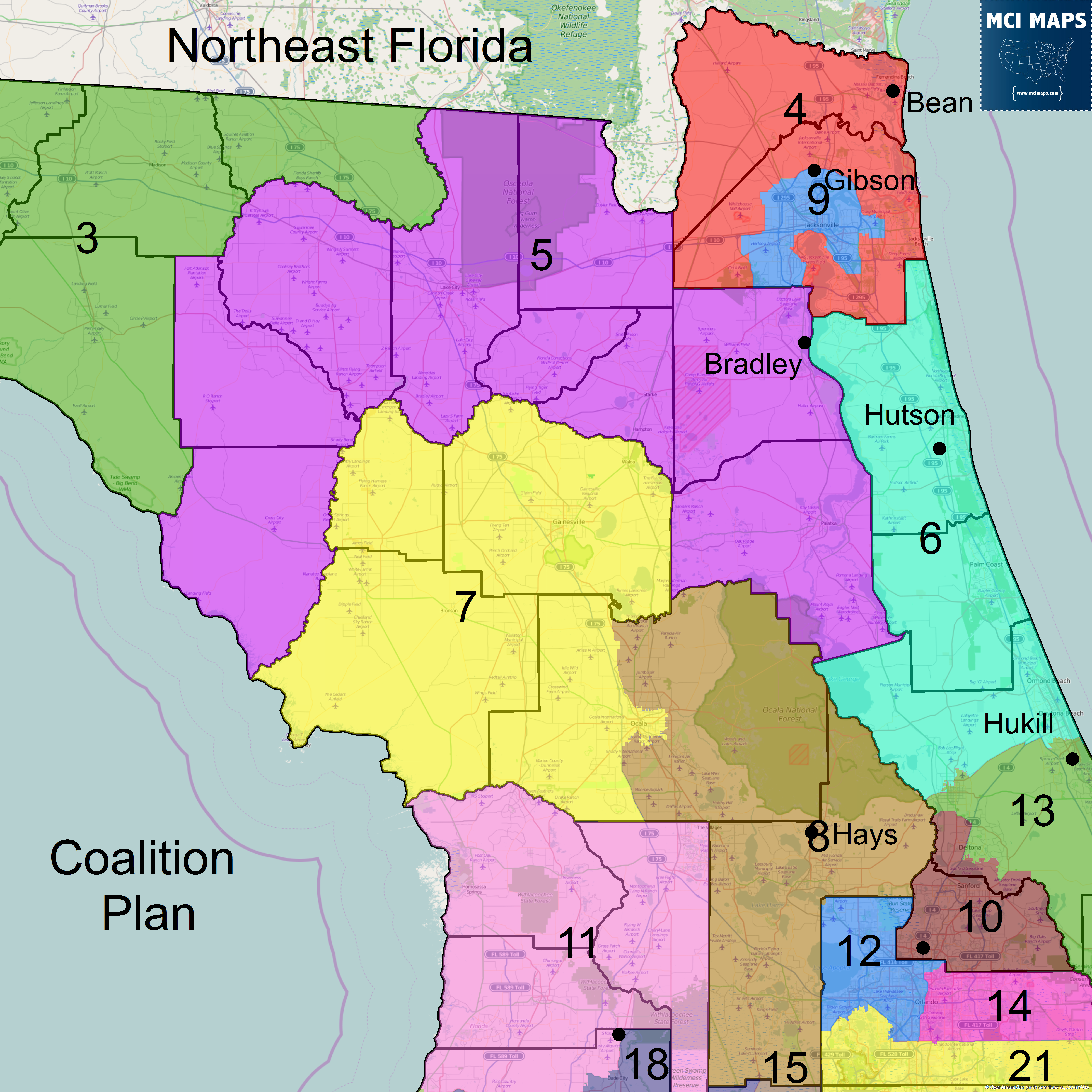
The big problem with this proposal is District 5, the upside-down U that goes over Alachua. This district is pairing the eastern counties of Clay and Putnam with western coastal counties like Dixie. While it is easy to simple write these counties up as rural counties (except Clay), they are from different parts of the state. The current 5th at least pairs many counties in the same region, including several on the coast. This plan would be better if the current 5th was used. I like the idea of the 7th taking Gainesville and Ocala and I have argued for that in the past. However, the plan could take in more of Marion and lose Levy and Gilchrist, allowing the current District 5 to be maintained. Putnam, Clay, and part of Marion could then be joined like they are in Senate Plan 9072.
Tampa Bay
Although the coalition recently handed over 2012 and 2014 primary data to the Legislature and with the ability to create a district that doesn’t cross the Tampa Bay, the coalition, for unknown reasons, opted to cross the bay anyway. In addition, they did so in a way that creates a district that is less black than the Senate’s current proposal.
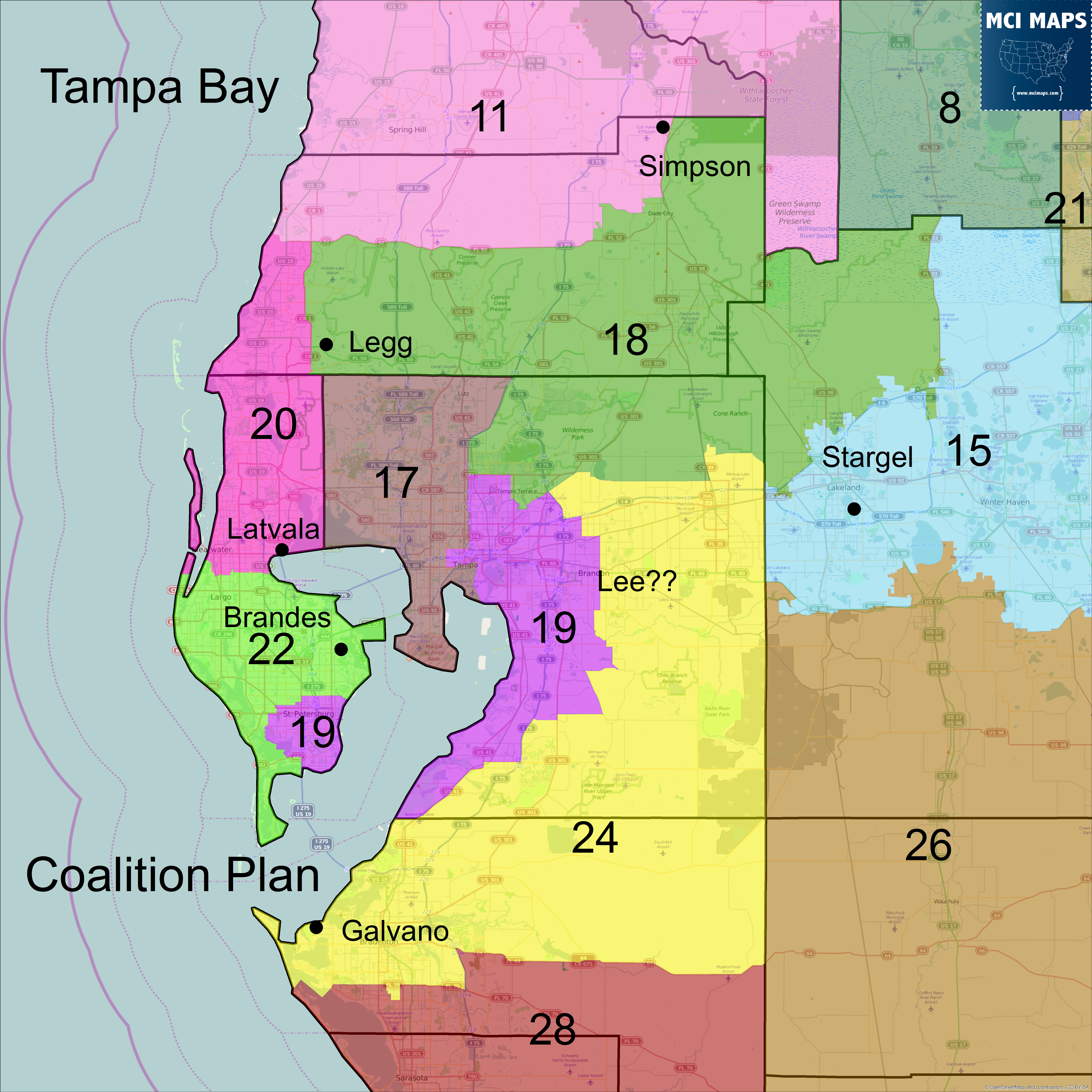
District 19 under the coalition plan is only 51.3% black in the 2010 Democratic primary. This is lower than the 52.5% under the Senate’s proposal. This is because the 19 takes in less African-American parts of Pinellas and Hillsborough, while not taking other diverse areas just north of its border. In addition, Pasco is split 3 times, which is the same as the Senate proposal but is unnecessary. Under this proposal the 17th would be a major battleground for both parties while the 24th may force Senators Galvano and Lee (whose exact address is not published) in a primary (if Lee isn’t in the 19th).
Orlando Metro
The Orlando plan is very similar to the Senate proposal.
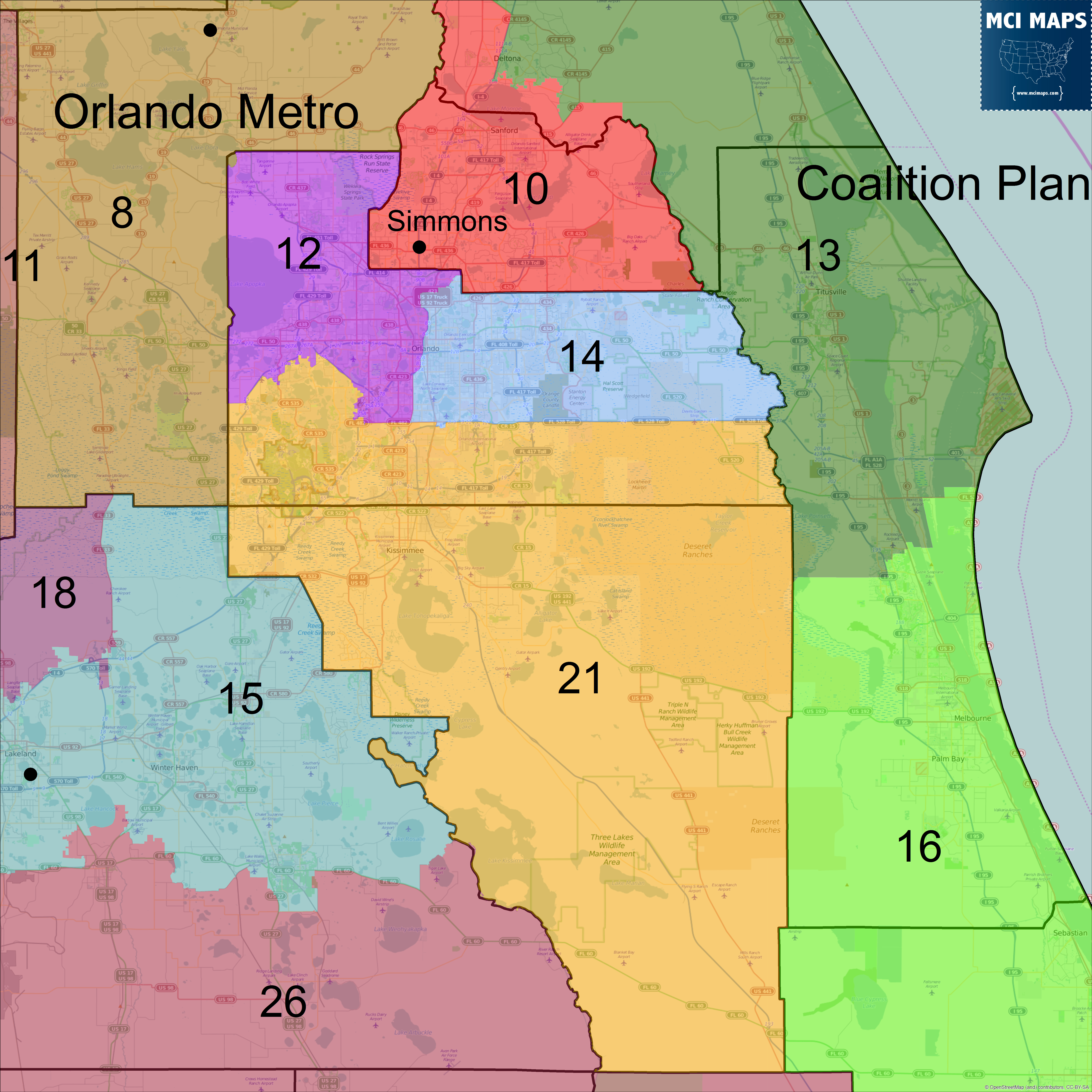
The borders are shifted slightly compared to the Senate proposal, but the overall nature of the districts remain the same. The 12th does take in some heavily white areas in the northern border of Orange, dropping its 2010 Democratic primary share from 53.8% to 52.2%.
Southwest Florida
Southwest Florida is similar and different from the Senate proposal in key areas.
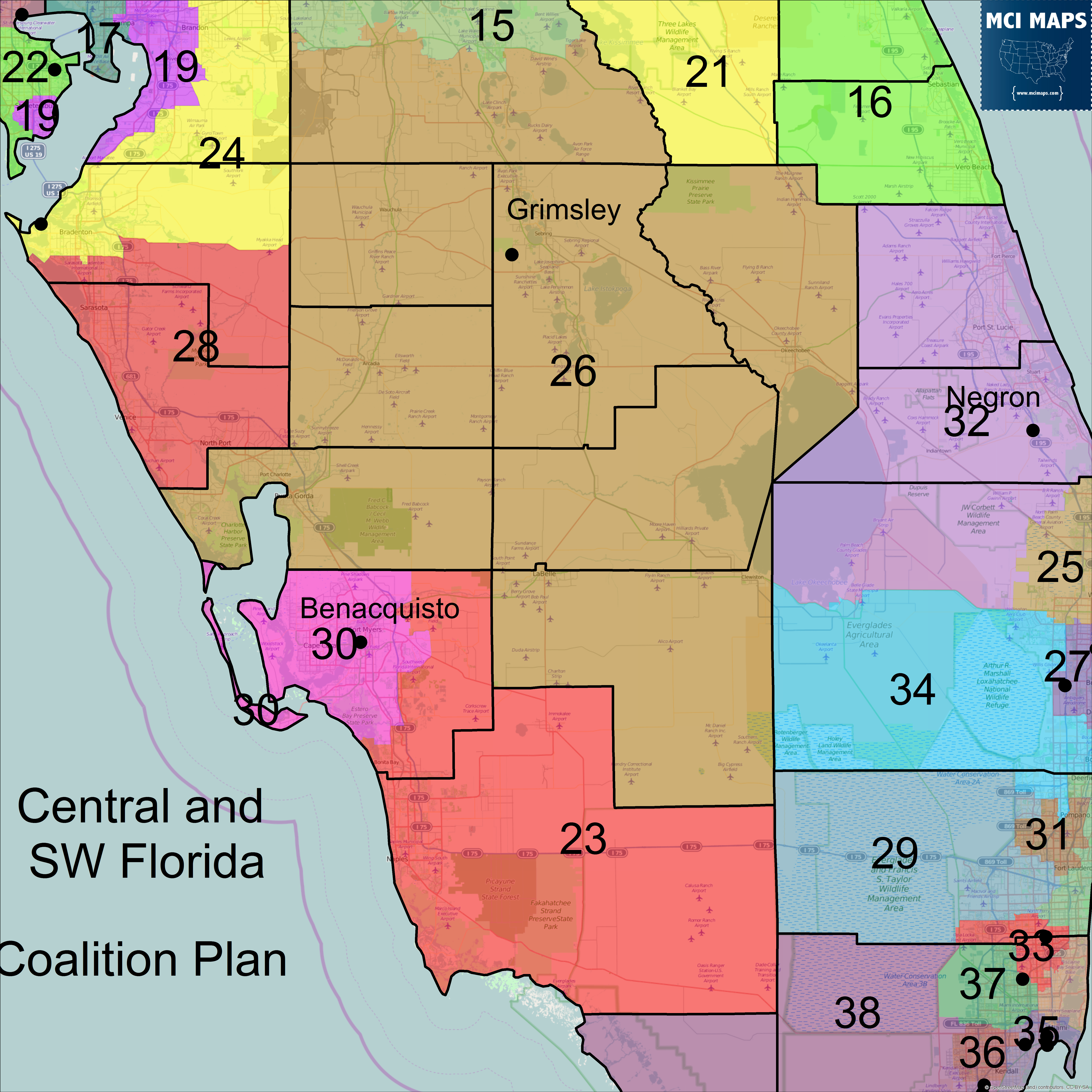
Collier and Lee are similar in the Senate proposal. In addition, Grimsley will be based in a united rural district of the farmland counties plus Charlotte. Negron’s district stretches into Palm Beach, taking in low population areas. That move, while affecting few voters, still means another split for the county. Sarasota is not cut in the plan, contrary to the Senate proposal.
Palm Beach and Broward
In Palm Beach, the inland district goes to the southern coast to even out population instead of the upper coast like it does in the Senate proposal. This ends up pairing Clemens, Abruzzo and Sachs together. The 34th also stretches into North Broward; pairing Parkland, Coconut Creek and part of Coral Springs with Wellington. This is a big flaw in the map. A Senate seat that pairs North Broward with Palm Beach should be doing so in the Boca and Deerfield area, not all the way up to Wellington. In Broward, the 40th hugs the entire coast, takes in south county cities like Hollywood and Dania Beach, and pairs them with parts of Deerfield and Pompano in the north. Meanwhile, the 31st is not majority African-American when it easily can be, an issue that could come up in a trial. The district leaves out large chunks of African-Americans while taking in whiter areas like Tamarac.

There are many adjustments needed in the Broward region.
Miami-Dade
The Miami-Dade plan is similar to base maps 9072 and 9074 with different border changes. The border between the 33rd and 39th is needlessly ragged and needs to be cleaned up. The 37th and 36th look fairly compact while the 35th is similar under other proposals. The 35th would lean Democratic (53% Obama), so it is unclear if Miguel Diaz de la Portilla would run for the seat (or if his brother, Alex, would either). Flores or DLP could look to the 36th, the only Romney seat in the area, as a safe zone, as the 38th is heavily Democratic in this map.
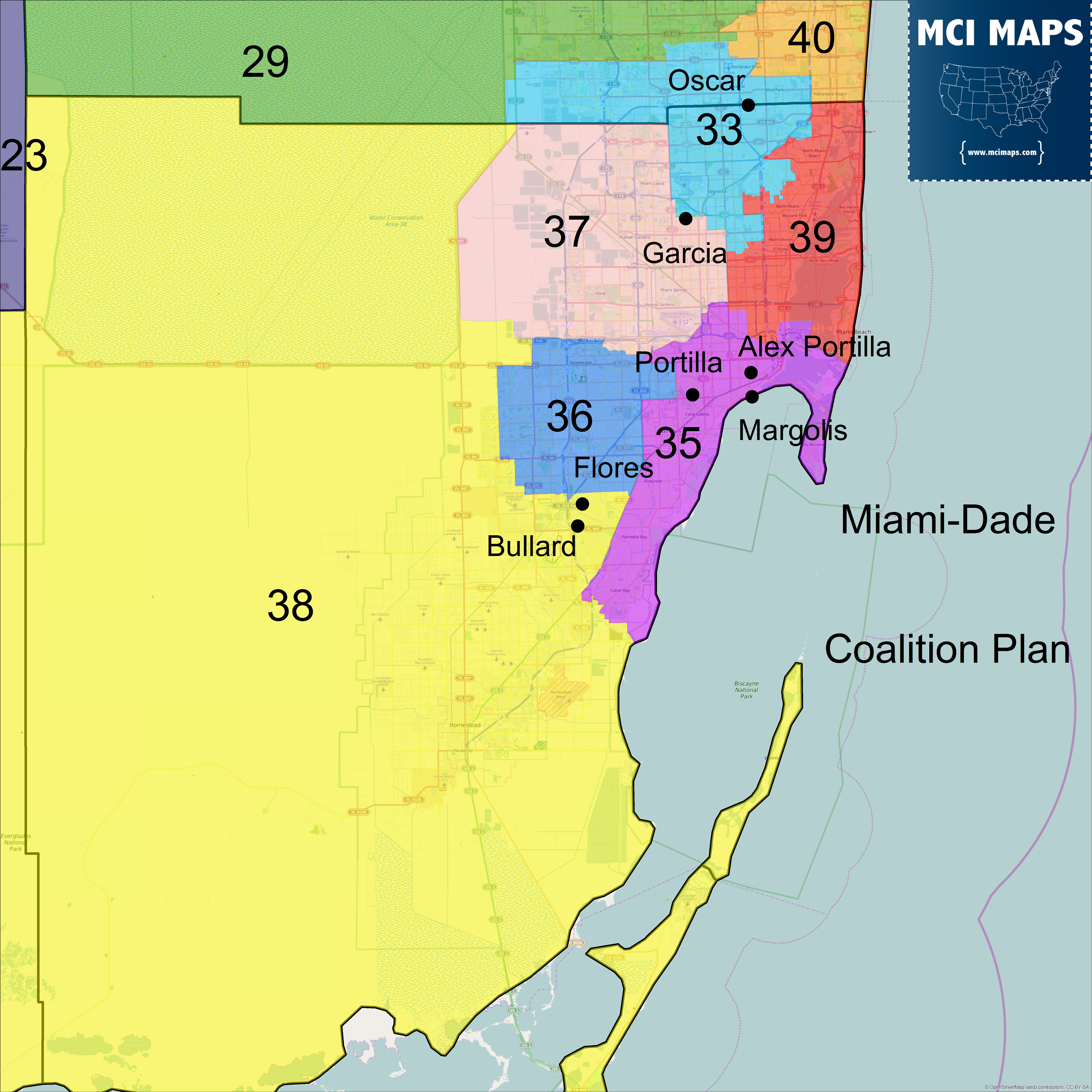
Overall Miami-Dade is not bad in this plan, similar to the base maps. However, it is very different from the Senate proposal now that DLP’s amendment passed.
Conclusion
Some aspects of this map are good, but some areas need to be wiped clean and started anew. The plaintiffs should create a map using the updated primary data they gave to the legislature and rethink Northeast Florida and the Broward county region. This map falls short in many parts of the state and needs some serious revising.
6 thoughts on “The Coalition Plaintiff’s Senate Proposal: Some key issues”
Comments are closed.